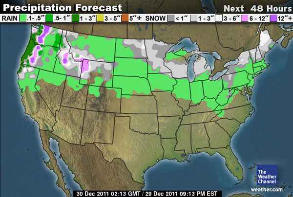
It’s time for the Friday Powder Alert and this week the snow is dumping on the Cascades and Northern Rockies from Thursday night through Friday night. A strong storm is pushing in off the Pacific with falling snow levels and snow will fly all the way to the base of the resorts. Lets take a look at the forecasted snowfall amounts at the summit of a some of the resorts by Saturday morning.
Let’s start with Mt. Baker in Washington where we should see 1.5 – 2.5 feet, The Summit at Snoqualmie 1 – 2 feet. In Oregon, Mt. Hood 2.5 – 3.5 feet, Mt. Bachelor 2 – 3 feet. In Idaho, Sun Valley 10-20 inches. In Montana, Big Sky 6 – 12 inches. In Wyoming, Jackson 12 – 18 inches. In Tahoe nothing so if you are out of work because if the lack of snow you should be on a road trip right now.
Here is TWC 48 hour snowfall forecast map.
Notice as well that in the Northeast a clipper system will bring a few inches of snow to the resorts with maybe 3-6 inches for the resorts in Northern Vermont including Stowe. There are even quite a few ski resorts in Michigan that will get snow if you are stuck there for some reason over the holidays.
After this storm there won’t really be any snow highlights until the next decent storm comes into the Pacific NW this time next week. The ridge is going to pump up the West Coast again this weekend into the first half of next week keeping any precip confined to Northern Washington. Mt. Baker could pick up some snow and then rain as snow levels rise with a couple of weak storms the first half of next week. The rest of the country looks to stay fairly quiet as well.
We will take another look with next Friday’s Powder Alert as the second week of January looks like the storms will return to the Pacific NW and Northern Rockies, maybe even a bit further South this time. BA


