
Some of the coldest air of the season has moved in over the Northeast behind the storm that brought rain and snow on Sunday. That cold air blowing across the still unfrozen Great Lakes brought snow squalls yesterday and a couple more inches of snow. Stowe is still picking up lake enhanced snows off of the still unfrozen Lake Champlain and has picked up 4-6 inches over the past 24 hours. That brings the total for the week to 10-15 inches and 57 inches on the season. Further South Killington is at 51 inches so far on the season.
The resorts have about 50% or less of their terrain open so far with a lack of big storms, some rain, and no holding cold in December. Today and tomorrow highs will on be in the single digits and teens with lows below zero. That will allow the snow guns to continue to open more terrain. The forecast stays cold enough for the next week to make snow around the clock but the temps will warm back into the 20’s to near 30 on Saturday before dropping back into the teens on Monday.
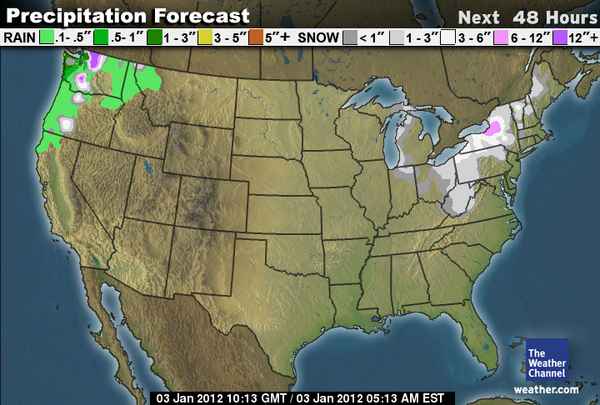
There are still no big storms in the forecast but there are small clipper storms that will hit the Northeast resorts about every other day for the next ten days. With each storm you only see a couple of inches at best but with most of the country starving for snow you can’t complain as long as you are getting some. The first one moves in on Wednesday night into Thursday adding an inch or two to the mountains. Here is the 48 hour snowfall forecast showing 1-3 inches through Thursday morning.

You can see the lake affect snow is still going over New York and Pennsylvania today which could bring a couple inches to the Poconos and Catskills. There is another clipper that will bring light snow on Saturday, another Monday, and then again next Wednesday. If the resorts of VT, NH, and ME pick up 1-3 inches with each clipper that could add up to 4-12 inches over the next 7 days on top of all the snow making that will be going on.
The European forecast model is suggesting that the clipper on Monday could phase with a storm coming up the East Coast over New England. That would bring a bigger snowfall event for Monday. The GFS forecast model sends the coastal storm out to sea but the GFS tends to correct back westward as the storms get closer so we will have to keep an eye on Monday’s storm. Many of the coastal storms so far this season have been rain but if this one materializes it should be snow.
Looking long-range there is some aggreement among the models of a possible coastal storm for next Friday. We will have to keep an eye on that one as well. The question may be will the storm track up over land bringing rain to start or along the coast bringing a decent snowfall event. Overall the pattern for the Northeast is going to stay active and fairly cold over the next couple of weeks.
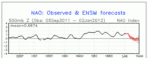
In order to get the big storms to become more of a reality and for the cold to lock in and hold for a while we would like to see the NAO (North Atlantic Oscillation) become negative. Here is the tracking chart as of today where you can see it is headed towards neutral and maybe slightly negative towards mid-month.
That would lead me to believe that the cold is going to try and keep pushing into the Northeast. Overall the thinking is that the La Nina pattern is going to take over bringing cold and snow to the West in January. That would put the trough in the West and the ridge over the Southeast. With the cold trying to push into the Northeast it should create a battle between cold to the North and warmth to the South. Battles create storms and this scenario is what had most forecasters calling for above average snowfall in the Northeast this Winter. So as we head through the month things might get more interesting. BA