Mt. Baker Has the biggest base in the lower 48 and we will add to that over the next several days. It is not unexpected that Washington would have the the most snow in a La Nina year, but normally we would see more snow and further South down into Oregon. There is currently a storm moving in that will bring snow through the day on Thursday and then more on the way this weekend and early next week.
The storm moving in currently has snow levels up around 5000 ft. but the snow levels will be dropping tonight and into the day on Thursday all the way down to 2000 ft. The ridge off the West coast is keeping most of the heavy precip up into Canada and the Northern half of the Washington Cascades. Baker should pick up around 6-12 inches at the resort by Thursday night. Higher up above 8000 ft. we could see 10-20 inches. The Summit at Snoqualmie is lower in elevation so it will rain a little longer before the changeover but we should pick up a few inches on Thursday.
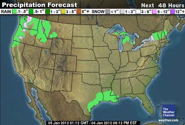
Here is the 48 hour snowfall forecast where you can see the 6-12 inches over Mt. Baker. There may even be a few inches over Mt. Hood.
You can see that with the ridge building off the West Coast again the storm activity is pretty quiet across the rest of the country. There will be another storm moving into Washington and Northern Oregon on Saturday. This storm is much weaker and should only bring a few inches of light snow to the Cascades.
The 3rd system will begin to move in on Monday with snow levels back up around 5000 ft. to start and then falling back down near 2000 ft. We could see several more inches with this system on the mountains. It’s not a big storm but it will continue to add snow to what is the largest snow pack in the country right now.
Then next week it looks like the ridge off the coast is going to shift Northward cutting off the storms to the Pacific NW and then inland into Canada by the end of the week. Next weekend the ridge will reform out in the Pacific near the Aleutian islands. That will allow lots of cold air to push into the Pacific NW. Then the storms shold start to come under the ridge into the West Coast the week of the 14th. Right now it is too early to say if the storms will focus on the Pacific NW or further South towards CA. We should have a better idea this time next week. BA


