We have been tracking the change in the pattern over the Pacific that is already underway this week. The ridge off the coast of CA has begun to shift North. With the stratospheric warming building towards the Arctic over the past several weeks we have been watching for the Arctic Oscillation to finally go negative and release the cold from the Artctic as well as setup blocking.
The ridge will begin to build near the Aleutian Islands towards the end of the week and then build into Alaska. This will setup a block with the storms going underneath and pushing the jetstream further down the West Coast. The big question is where will the ridge setup near Alaska. The forecast models are split on whether it will setup more over Alaska and into Western Canada pushing the storms South into CA, or further West into the Bering Sea allowing the ridge to build back off the coast of CA while the storms hit the Pacific NW.
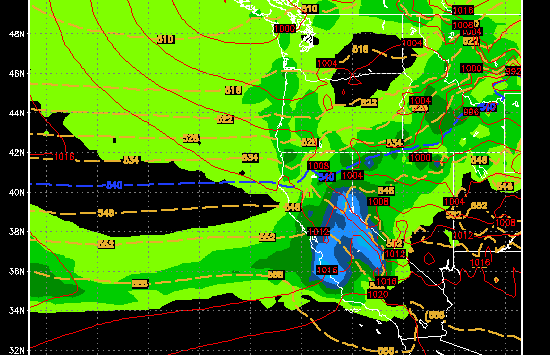
Watching each run of the forecast models has been maddening as the go back and forth. Yesterday’s GFS had the storms while the European and Canadian models were dry. Today they are flipped the other way with the GFS now dry and the Euro showing some big storms next week starting on Tuesday. Here is todays 12z deterministic run of the Euro for next Wednesday in the heart of a storm that would drop 3-4 feet in a 36 hour period.
and here is the total 36 hour precip map showing 3-4 inches of liquid.
But for a reality check here is today’s 12z GFS for the same day.
We may see this back and forth for a few more days as the models are really struggling with all the changes going on in the pattern. The 12z ensemble run of the Euro shows the storms continuing for at least a week starting next Tuesday. The 18z GFS keeps them just to the North all week but the latest 0z GFS run that just came in has the snow again for next week. The Euro has had a better track record with long-range forecasting.
With the Arctic Oscillation going negative we could see more of the blocking pattern going into the end of January and into February. That will keep the overall pattern much different than that past couple of months and the chances for a stormy pattern to develop. By this time next week we should know our answer on whether or not the big storms start next week. BA

