We have been watching the forecasts for a pattern change over the Pacific for mid-month and it is now underway. The ridge off the West Coast will be replaced with a trough as the ridge builds up over Alaska and low pressure sets up off the coast of Canada. That will direct a series of storms into the Pacific NW starting this weekend as the jetstream comes underneath. This pattern looks to last at least a week or more.
Not only will there be precip but plenty of cold air with snow levels starting off as low as sea level in Washington this weekend. The snow levels look to stay low enough through next week for all snow on the Cascades. There is still a question as to how much snowfall as it is still early and exactly where the heaviest snow will fall, but it will be in feet and significant. Right now it appears like the heaviest snow may fall over Oregon but with plenty to the North over Washington and South over Northern CA.
The snow should begin to fall Saturday night in Northern Washington up near Mt. Baker and then spread South through Oregon over the weekend. There will be lots of cold air coming in with the initial wave of snow over weekend with snow levels getting down close to sea level so there could even be some snow in the cities. Then snow levels will fluctuate through the week but they should stay low enough for all snow at the resorts.
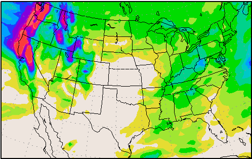
Here is the wxmaps.org map showing the total precipitation from Saturday-Saturday.
You can see 3-4 inches of liquid up near Mt. Baker and down near Mt. Lassen with 5-6 inches over much of Oregon. It can actually go higher into the black beyond 6 inches. With the cold air we could see temps in the teens and 20’s on the mountains through the period which would create snow:water ratios of 15-20:1 so you do the math. Even at 30 degrees you can pretty much equate the inches of liquid to feet of snow. So if this precip map were to verify that would be a minimum of 5-6 feet for the mountains of Oregon and 4-5 up into Washington.
That is only through Saturday and the long-range models suggest that this pattern could continue into the following week. It’s a La Nina season with La Nina holding steady in the moderate range, so it’s about time we see a La Nina Pattern in the Pacific NW. The forecast for the Pacific North American teleconnection which has been positive since November is for it to go negative by mid-month. That would favor the trough and storms staying near the West Coast through the end of the month. BA


